Sunday, May 19, 2013

The Only Thing Worse than Your Bus Being Late

I was reading comments at the DelDOT Facebook page the other day. I noticed a comment from someone complaining about his bus leaving 15 minutes late from Rodney Square. I’m sure everyone who uses DART has had that experience more than a few times. I think we usually understand and make allowances for late buses. Traffic is unpredictable, and just one wheelchair boarding can set a schedule back 5 minutes. We get annoyed when our bus isn’t on time, but we understand... kinda.

But what riders find impossible to forgive is when they miss a bus because it left early. There were comments about that, too. The worst of all is when a bus is parked at a transfer point, such as Rodney Square, and after waiting for passengers to board for 5 or 10 minutes it leaves... ahead of schedule. I’ve seen buses leave Rodney Square anywhere from 1 to 6 or more minutes ahead of scheduled departure. And, like the passengers who commented on DelDOT’s page, I’ve missed buses because of such early departures.

An early departure infuriates riders for several reasons:
  • It can cause you to miss your ride or your transfer. I can hardly express how infuriating it is to hurry off your bus to catch a transfer, only to have the second bus pull out when you are feet from its door, and then to realize it wasn’t scheduled to leave for 2 more minutes. And then you have to wait 30 minutes or an hour for the next bus, just because some driver couldn’t wait 2 minutes and leave at the correct time.
  • There is just no excuse for it. Drivers are in total control of when they leave a stop, especially a transfer point like Rodney Square. They may not be able to control traffic and other issues that can cause delay in their schedules. But an ahead-of-schedule departure is totally their (bad) choice. And it's a slap in the face of the ridership, a screw-you gesture from the offending driver.
  • The fact that these incidents keep happening over and over is indicative of a lack of supervision and commitment to excellent service on the part of DART management. It becomes apparent to riders that managers are neither adequately training nor supervising drivers. 

Personally, I used to see this happen all the time when I transferred from a Route 40 bus to Route 19. I’d usually arrive at Rodney Square in the early evening, usually a little late because Route 40 is often slowed by heavy traffic. I’d rush to find the Route 19 bus, sometimes only to have it pull out early, leaving me in its dust. So I complained to DART, using the complaint feature on its website. And guess what... that driver just kept on leaving early. I’d sit on the bus each evening and time the departure, and more often than not it would be early... one minute, two minutes, three minutes. Not a lot, but just enough to cause people to miss their rides. Since I had complained more than once, I expected the situation to be corrected, but it never was. This specific driver just continued to stick it to the riders with no consequences, so far as I could see.

I wonder about why some drivers tend to do this, to leave early. Do they have watches or clocks on their buses? Are their watches/clocks checked so that they aren’t fast or slow? Some drivers are probably just impatient, or maybe, as with my former Route 19 driver, it’s the last trip of their shift and they want to finish a little early, or use a restroom, or have a meal. But maybe some do this in order to get a jump on their schedules. Is there pressure on drivers to get to their destinations on time, such that they feel pressured to take little shortcuts like leaving early? I wish I knew.

This situation has been going on for years now and is still going on, despite passenger complaints. What’s wrong with DART management, with its training and supervision, that it has still not been corrected? This is not a sign of a well-run transit agency.

Friday, May 17, 2013

Is Delaware's Walking Environment Friendly? Hostile?

There is no dispute that walking is good for the environment and as well as for your health. A news item published earlier this month, titled Improved Walking Environments Can Benefit Mental Health, authored by Robbie Weber of the State Smart Transportation Initiative, points to research-based proof that walking as exercise helps school children concentrate better and seniors maintain cognitive function.

The article observes that walking is relatively easy, and requires no equipment except a pair of good walking shoes. However, it notes:
"...there is one other element that might be harder to come by: a safe place to walk."
According to Weber, the total number of US traffic fatalities has fallen by 24% in the last 10 years, but the percentage of those deaths involving pedestrians has risen during that time. Delaware itself has the second-highest rate of pedestrian fatalities in the nation, according to an April 11, 2013 News Journal article.

State officials seem to be primarily blaming the pedestrians for this. But another likely element in the increased ratio of pedestrian deaths, in the nation as a whole as well as here in Delaware, lies in what Weber terms hostile or dangerous walking environments that may, in part, arise from car-centered improvements to our roadways. For instance, as we make it easier for cars to travel, higher travel speeds are encouraged and danger to pedestrians, bicyclists, and transit users may increase.

I believe that there are yet more elements at play in making our roadway areas hostile to pedestrians. In lower-speed areas within Wilmington city limits, these elements may not result in fatalities, but at minimum they make it scarier and more difficult for pedestrians to get around, and discourage people from getting out of their cars to use transit, bicycles or their feet to commute or run errands.

One element is planned changes to our roadways that benefit motorists at the expense of pedestrians. You wouldn't think these things would be happening given state and local government's stated intention of encouraging public transit, bicycle, and pedestrian travel. But right here in Wilmington, we've seen removal of crosswalks that are located at intersections without stop signs or traffic lights.  This certainly makes things faster and easier for drivers, but rather than encouraging them to keep in mind the potential presence of pedestrians crossing the roadway, it encourages them to think that the motorist's right-of-way is supreme, and that they don't need to worry about people on foot or on bicycles.

I frequently walk along Bancroft Parkway in Wilmington. It's a pretty tree-lined street with a greenbelt, lots of shade in the summer, and without the heavy traffic and car exhaust of nearby, parallel Union Street. It's ideal for walking or biking. There once were painted crosswalks at the intersection of Bancroft Parkway and 4th Street, and I've been told at Lancaster Avenue also. But when roadways at these intersections were resurfaced (the one at 4th Street just a couple of years ago), the crosswalks were not repainted. Pedestrians will surely continue to cross at those locations, but now without even a reminder to motorists that pedestrian crossings are frequent.

The second additional element creating a dangerous and hostile walking environment is the motorists themselves. When I cross at green lights here in Wilmington, I am constantly being cut off by drivers, who will often drive their cars aggressively to within inches of my path, as if they own the road and I'm the interloper. And there is certainly little understanding of pedestrian vs. car rights-of-way at intersections in which the green pedestrian signal is lit. It often happens that a driver will nearly drive over my feet as they make their turn, despite the fact that I have already started to cross and have the right-of-way. Worse, I've had police watch this and do nothing. Nobody in Wilmington ever seems to get ticketed for violating the right-of-way of a pedestrian. Hence this rude, intimidating, and dangerous motorist behavior continues.

We've heard that Delaware officials are concerned about our state's high rate of pedestrian fatalities. Based on my own observations and the information in Weber's article, it is clear that Delaware, if it wishes to improve its statistics, must create changes that make walkways less hostile to pedestrians, even if it may mean a bit more inconvenience to drivers. The current "cars rule" mentality that seems to pervade the thinking of both transportation planners and motorists here in our state is surely a large, and it appears largely unrecognized, element of the relatively hostile and dangerous walking environment that is  reflected in our pedestrian fatality statistics.

Wednesday, May 15, 2013

Riders Again Inconvenienced by Downtown Detours

Road closures and bus re-routing have been announced for Downtown Wilmington again this weekend. I love these events, but the disruption of bus service that they cause presents a serious difficulty to Saturday commuters. This is just another of many good reasons for re-locating the Wilmington transit hub to the train station area.

I've gotten DART alerts on my phone about road closures and downtown bus detours for the past two weekends. This Friday evening and Saturday, buses in the downtown area will be on detour for the Grand Prix bicycle race. Last weekend we had a marathon and a visit from the King and Queen of Sweden.

A couple years ago I had a Saturday morning job down in the Bear area. It involved teaching a class at a set time. Being just a little late wasn't an option. A lot of people work on Saturdays, and being tardy isn't an option for them, either, assuming they want to keep their jobs. Many of these folks ride a bus to the Rodney Square transit hub, and then make a transfer to another bus that takes them to their workplace, which is what I did. 

This kind of weekend commuting tends to involve a LOT of waiting time. Buses run less frequently on the weekends. It was also my observation that they were even less likely to run on time on Saturdays, which really doesn't make sense given lighter weekend traffic. However, I've been told that weekend bus drivers tend to be inexperienced, the newer hires. So maybe that's it. But I found I needed to get to my bus stops really early, because sometimes the bus would arrive as much as 15 minutes ahead of schedule... or be behind schedule by as much or more. And I had to allow at least 20 or 30 minutes for a transfer at Rodney Square, for the same reasons. Fortunately, I was never late for those Saturday classes. But I had to allow over four hours for the round-trip commute, about 13 miles each way, to a two-hour job assignment. (Google Transit gives a 1-hour trip time, but because they allow only a very unrealistic 5 minutes for the Rodney Square transfer, that would almost never work.)

Now, if you are just coming into town on Saturday to shop or go to the office, downtown road closures and bus re-routing won't affect you much. You may have to get off at a different stop and walk a little farther. But if you need to change to another bus, it can be a nightmare trying to find your bus and make your transfer so as to get to work on time.

This is how DART's e-mail alert for this weekend read, in part:
DART Bus Route 2, 21 & 35 will be on detour. Also notices at affected Friday bus stops will instruct passengers to board on Broom Street at 20th Street or on 18th Street at Van Buren Streets. For the 18th, most transfers will take place on Shipley Street between 10th Street and 9th Street. Notices will be posted to direct passengers to which bus stops oard (sic) dring the detour.
Clear as mud, eh? Notice the lack of any precise information a rider could use to plan his trip, and decide whether he needs to allow more time and come in on an earlier bus? Notice how it sounds as if in some cases riders will need to go to their original stop to find a redirection notice, and then walk an unknown distance to another location, adding time to the commute that cannot, based on information provided by DART, be estimated in advance? Notice the lack of any kind of map showing temporarily re-located stops and routes?

I am heartily in favor of siting these types of events downtown. The races, parades and festivals add vibrancy to our city, provide local and low-cost entertainment for city residents, and undoubtedly bring a lot of money to local restaurants and shops. I would be the last person to suggest eliminating them or moving them.

BUT... the disruption of the local transit hub at Rodney Square is a big hardship to a lot of Saturday commuters. DART's lack of precise information about relocation of routes and stops makes things even worse for its riders. 

I think it's high time for DART and Wilmington city leaders to begin the planning for moving the transit hub to a nearby area that will be more accessible and less prone to disruption during downtown events. The train station area has always been cited as the logical location for a comprehensive transit hub, and I agree. It's past time, guys. 


Monday, May 13, 2013

This isn't exactly news, but since Dart announced, with lots of fanfare, the advent of its mobile website, I've wanted to write a review. And... I give it 1-1/2 stars out of five. In short, I found it to be pretty much a waste of time, a bit of a joke. It's almost useless to me.

Now, I was pretty excited when it was first announced... when I checked it out, not so much. You can visit the site at this URL, which you can also find on the DART home page, up at the top right. (It’s easy to miss.) I've also added it to the list of useful links on the sidebar to the right of this blog.

One of the main things I’d like to be able to access on the mobile website is, of course, bus schedule information. But when I click on “Routes & Schedules,” it takes me to a county selection page, then to a route selection page, and finally... ta tah!... to a teensy weensy version of the same humongous pdf of the paper schedule that you get from the main website. Even with a magnifying glass, this is unreadable on my Blackberry. Maybe it would work on one of those expensive, nearly-tablet-size smartphones. But it doesn't help me, and it won’t be usable by most smartphone users. Sure, most browsers, if they can view pdf files, can also magnify portions of the page. But with bus schedules, you need to see more than little magnified bits. You need to see the header, to get the stop ID, and then way down the columns for the arrival times, at which point you've lost the stop ID headers. Not to mention that it is easy to get lost and be looking at a Saturday schedule when you think you're looking at weekday times. Big pdf tables, in other words, just don't work well on smartphones. So all this schedule stuff... not usable.

So maybe the Trip Planner would work better? When I clicked on that button, it took me to a page that calls itself a DART Google trip planner and asked me to put in my departure and destination address, along with date and time. When I entered said data and clicked to get directions, it took me to... the Google home page. The main search page, not even a map page. Now I use a Blackberry. This feature works better on my laptop browser, and presumably may work on some smartphones. But it was apparently not checked comprehensively.  

Not to mention that it's easier to just go directly to the Google Map website, because that's all the DART page does... allow input of your data in a manner no easier to use than Google's, and then transfer it to Google and open Google's map showing your route. You can do this yourself on any phone that can access Google Maps, or even better, that has a Google Maps app. This DART mobile feature is kind of a sham and adds nothing new. It's just an overlay making it look like they've done something. They haven't.

So, what is the DART mobile page good for?
  • You can click on “Rider Alerts” to find out if there is anything happening that could affect your trip. But if you use DART transit, you should already be signed up for DART alerts via text messages and e-mail. Plus, as I've learned since they started a big DOT construction project in my neighborhood, DART no longer seems to feel the need to alert riders about temporarily defunct bus stops. 
  • You can get a list of DART contact phone numbers. Of course, if you have a smartphone you can also get this from the main website without much trouble, so the mobile version isn't really needed.
  • DART can congratulate itself on having a mobile site to serve its customers. (The fact that they can’t use it to do much of anything likely won’t prevent them from claiming this.) I suspect this may actually be the most important function of the mobile website.
Now, one of these days we'll be able to access something like NextBus and get real time bus arrival time data for our trips. And we'll surely link to that from DART's main and mobile web pages. That will be worthwhile. But this effort seems mainly pro forma.

Friday, May 10, 2013

Delaware is Bicycle Friendly? Really?

May is National Bike Month, and according to the League of American Bicyclists, Delaware ranks fifth in the nation for being bicycle-friendly. Their scorecard for Delaware is available for download. Also, based on an April 2013 fact sheet from the USDOT National Highway Traffic Safety Administration (NHTSA), in 2011 Delaware had no bicycle fatalities at all, compared to 5 for Maryland and 6 for Virginia. So Delaware cyclists aren't getting bumped off at high rates. But as to the "friendliness," I guess rankings like these depend on the metrics used.

When I first moved to the Wilmington area ten years ago, I used to ride my mountain bike all over New Castle County. It was great exercise and environment-friendly, but it was very, very scary. These days I mostly walk or ride the bus. But I remember vividly how difficult riding a bike was in many parts of New Castle County.

Out in the hinterlands of Greenville, Hockessin and Centreville, many roads consist of two narrow, winding lanes with little or no usable shoulder. It's beautiful out there, but dangerous for cyclists. I was always narrowly avoiding being mowed down by some suburban housewife driving to lunch or to pick up the kids, cell phone clamped to one ear, barely capable of controlling the behemoth SUV she was driving at a rate of speed that caused her to veer into the oncoming lane (where I was) at every curve. And no, I'm not being sexist, it really was always a female driver.

Riding is actually a little easier here in the city. But there are still a lot of drivers who think they own the road by virtue of having the bigger vehicle. They do the same thing to cyclists that they do to pedestrians. They ignore right-of-way laws and aggressively cut you off at every opportunity. As far as I've been able to tell, Wilmington police simply don't enforce these laws and motorists never get ticketed for their antics (even when directly observed by a police officer, as I've seen too many times), so drivers merrily continue this annoying and dangerous behavior.

It's true that we have very few "real" bike trails here in New Castle County. Most involve "sharing" the road with cars, and you know how that goes.  When you get to your destination, it's unlikely you'll find any kind of bike rack, either. Probably as a result of these issues - rude drivers, lack of separate trails for bikes, and scarce bike parking facilities - not many people here in the Wilmington area use bikes to commute, or even just to get around to do errands. Indeed, one area in which Delaware did not rank well, according to the NHTSA fact sheet, was percentage of population using bikes to commute. And of course, this certainly contributes to our low bicycle fatality rate. When hardly anybody is out there riding, there's nobody to be knocked off their bike and killed.

So Delaware's areas of needed improvement for bicycle-friendliness, per the NHTSA, include:
  • Increasing the number of people using bicycles to commute to work;
  • Adding a bicycle emphasis to a strategic highway safety plan, and
  • Providing bicycle education for police and schoolchildren.
Based on my experience as a bicyclist here in NCCo, I'd have to say that while infrastructure is important - bike lanes, bike racks, etc. - education and enforcement of the laws that protect bicyclists from motorists may be even more important. As long as drivers are allowed to terrorize bicyclists with impunity, most people will be reluctant to give up their cars and take to their bicycles.

Beefing up the laws that protect bicyclists and pedestrians, and then implementing them in the form of an active, ongoing ticketing campaign, would go a long way towards making motorists more polite and compliant with applicable laws. Unfortunately, as with cell phone and seat belt laws, too many people are motivated more by the fear of a hefty fine than by safety concerns.

Wednesday, May 8, 2013

Are NextBus and Real-Time Data Coming to Delaware?

I'm really, really interested in having real-time bus data here in New Castle County. Anxious even. This is the one thing mentioned in the SSTI transit report that I think should be rolled out as soon as possible. This kind of data is already available to riders in some metropolitan areas, including Los Angeles, Washington DC, and San Francisco. The system tracks buses using a combination of GPS (global positioning system), AVL (automatic vehicle locator), and smart phone technologies. It then allow riders with said smart phones to check on the location and estimated arrival times of the buses they want to ride.

If you want to learn more about this system, go to Nextbus.com and have a look. And here's an interesting surprise: DART is listed! Click on the "Select Your Transit System" button on the right, scroll down to Delaware, and you will find DART. Only Routes 201-208 are shown, and they don't appear to be active yet. Could they be getting ready to roll these out for the summer tourist season?

According to what I've read, using a smart phone you go to the NextBus website for your transit system, click on your route and your stop, and then get information about the next buses serving that stop. The screen shot example to the right also appears to give information about other bus routes serving your stop, which can sometimes be very useful.

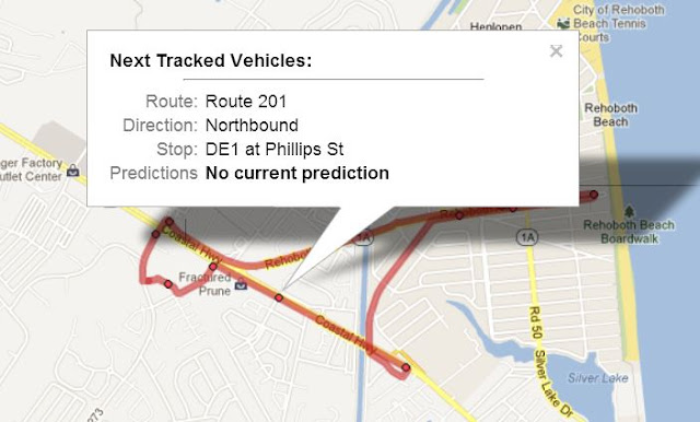
Another way this can work is by selecting your route and then clicking on a map. I selected Route 201 and then clicked on the Google Map (because it's what works on my Blackberry). The map shows the route and bus stops. I clicked randomly on a stop, and here's an example of what we'll be seeing, except that there should also be a real-time prediction of the next bus arrival times at the stop I chose.


This is just so cool! So if the bus is running late, or early, I can know and be ready. I've read that on some systems, smart phone users can actually see the bus moving along its route on the map on their phones. Also, I see from the NextBus website that a variety of other ways to access information are available, including text messages and information from an automated phone system. I don't know what features we'll eventually have here in Delaware. One nice thing: there are no direct charges to users of the website. I'd imagine, however, that the site is funded by the various transit systems.

I think a system like this, rolled out for the whole state, would go a long way towards increasing ease and satisfaction of use for DART riders. The most frequent complaints I hear, from both riders and non-riders, is the problem  of missing buses because they run early or late, and especially the delay and anguish this causes when a bus is missed when trying to make a transfer on a long trip. This is one of the primary worries cited by non-riders I've met as reason they don't consider riding the bus.

For a lot of reasons, DART buses are unlikely to be reliably on time in the near future. But having this kind of real-time information will make it much easier for riders to plan trips and make quick changes in plan when conditions dictate. This will certainly makes  riders trips quicker and lives easier. Importantly, this will also give them a feeling of greater control. Riders who transition from cars to transit definitely suffer from a feeling of helplessness, of loss of the control they felt when they used their own car. Real-time transit information will, I think, restore some of that feeling of control, and make transit use more attractive to a greater number of people.

Another thing I realized is that this service will be wonderful for people with vision or mobility problems. Identifying and making your way to your bus at crowded stops, where a lot of buses arrive in quick succession, can be difficult for even marginally handicapped folks. Knowing where your bus is and how soon it will arrive will be very, very helpful to this category of rider.

My understanding is that DART already has GPS-based AVL on some or all of its buses. So let's hope they are able to roll out this system state-wide sooner rather than later.


Monday, May 6, 2013

The Full Wilmington Transit Report

Good news: we can all read the full transit report that was discussed by the News Journal last month - Reimagining a Legacy Transit System: Lessons from Wilmington, Delaware, published April, 2013.

I discussed this April 27 article in this blog post. I did not realize until recently that a link to a pdf file of the full report had been added to DART's website. It's not a long report, just 9 pages, and although it contains some jargon, I found it very interesting.

The report is more nuanced than I expected based on the News Journal report. I was disappointed to see that it failed to address the scheduling stupidity that directly CAUSES most stacking of buses at Rodney Square. I don't know why every report, whether by the News Journal or a government entity, fails to acknowledge this fact. Maybe it's not really apparent unless, like me, you've spent many hours sitting at Rodney Square, watching the buses come in and then go out. Or maybe it's purposeful, for some reason not discernible to me.


By the way, I was curious about the authorship. I Googled State Smart Transportation Initiative (SSTI) and discovered a set of slides, in pdf format, that were used in SSTI's April 26 webinar regarding their report. Some nice photos and maps!

SSTI appears to be a University of Wisconsin-based organization with around 20 state members and a smallish staff. Although I found no funding information on their website, I''d guess they are largely funded by state and federal grants. They appear to issue reports and newsletters and to host webinars and meetings regularly.

It's nice... really nice!... to see DART appear to be pursuing viable short- and long-term solutions based on what appear to be state-of-the-art research and technical approaches. Now, the challenge is to get some of the great ideas in SSTI's report implemented, or even just to get our local governments and DART to pay attention and start making some concrete decisions and plans. Whatever, the report is certainly worth reading by anyone who uses or cares about public transit here in New Castle County. 

Friday, May 3, 2013

No DART Notice about Construction on Lincoln?

DelDOT has recently begun a big project on the far west side of Wilmington. They got things underway The project involves improvements to the roads and some sidewalks along S. Lincoln and Union Streets at about Sycamore St., on the far west side of Wilmington, and continuing on to the south to include Kirkwood Highway as far as Elsmere, from what I understand. The beginning of the work is focused on the area around the intersection of Lincoln and Sycamore, as shown on the map.

I notice that although the bus stop on Lincoln at Sycamore is inaccessible (and unusable), there has been NO announcement by DART of this closure, none of the usual Rider Alerts. As of yesterday, not only was the right lane of Lincoln blocked off in this area, the sidewalk where the stop is located was being replaced and the whole area along the east side of Lincoln was inaccessible to pedestrian traffic. I do not understand why this is not included in DART's rider alerts!

This project will last through this spring and summar. Users of Route 6, which runs between Rodney Square and Newark, along Kirkwood Highway, Lincoln St., and Union St., are going to need a lot of patience. They will often need to allow extra travel time I would guess. Already, with just the sidewalk replacement work at and near the corners of Lincoln and Sycamore, the closure of the right lane of traffic is causing a lot of traffic to stack up at the lights during rush hours. This will inevitably delay the buses.

The roadwork does appear to be needed. Kirkwood Highway just south of the area shown on the above map looks like a patchwork quilt. Still, bus and other vehicle travel will definitely be affected. I just wonder why we're not getting word of this from DART, as we have done about road construction in the downtown and Christiana Mall areas? This is also a very heavily travelled area.

Wednesday, May 1, 2013

How to Find the Closest Bus Stop

When I first started riding the bus, once I figured out which bus route I needed to use to get where I was going, I then needed to know at which stops I should get on and off. That was a little tricky, and still is. DART's paper bus schedules only show a few of the available stops along the way. More complete planning tools are often needed. The best I've discovered are:

DART's spreadsheet-format listing of all bus stops in Delaware 
You can get to this downloadable table from the page on DART's website where you access bus schedules. If you use these tables, you'll notice that the far left column is for the route number, starting with Route 1. All the OUT (outbound) stops for a given route are listed first, then all the IN (inbound) stops for the same route. (In case you didn't know, "outbound" means the route going away from Rodney Square or other transit hub, "inbound" means heading towards the hub.)

This list is NOT smartphone-friendly, and is hard to read even on a laptop computer. Stop locations are not always specific or clear, either. But it is up-to-date and includes all current stops. If you print it out, keep in mind that it may change twice a year, whenever the new service changes are rolled out.

Google Maps with the transit overlay, or Google Transit
These Google maps are much more usable than either DART's paper bus schedules, or the tables referred to above. Under the option "Get Directions," Google lets you list your departure and destination addresses, click on the "transit" icon, and then get directions for one or more alternative bus or train routes. The directions include bus route information, and show how far you need to walk (or take a taxi) to your destination address. You can even plug in desired departure or arrival times, and get some idea of when you need to get to the bus stop or train station, and when you will arrive. Very, very quick and helpful.

The local Google map will show little blue bus stop icons ONLY IF you have the transit overlay option selected. Keep in mind also that stops are only shown when you have zoomed to a fairly large scale version of the map. However, Google's maps, including the transit overlay, seem to work really well on almost all smartphones, tablets, and computers. I can even use this on my old Blackberry. Works perfectly, if not at lightning speed!

Be aware, however, that Google's data for stop locations and schedule times may not be totally complete nor up-to-date. Especially after a service change, you might want to double-check stops and especially times. In the past, I've noted a few stops that were not shown on my phone's Google map. (These were of course included on DART's bus stop table.)

Another thing to be careful of is Google's assumption that buses run approximately on schedule. We DART passengers know differently, don't we? Realistically, the Google transit directions often need to be tweaked to allow enough time at transfer points. My experience has been that it I need to allow at least 15 minutes for a transfer at Rodney Square. Even so, I'll still sometimes miss my transfer, due to tardy arrivals and (even more annoyingly) ahead-of-schedule departures by a some drivers.

Dart Drivers
Some of the best sources of information about routes and bus stops are the DART drivers. I've never failed to get reliable information from drivers. However, they may not necessarily know the locations of destinations or landmarks that you use to determine the best bus stop to get off. So I like to do my own homework beforehand. 

Monday, April 29, 2013

Resumed Transit Hub Discussion for Wilmington?

Once again the subject of a real transit hub for Wilmington is being discussed. And it's about time! The News Journal, in a Saturday article (April 27, 2013), discusses a report that was recently released by the State Smart Transportation Initiative, whatever that is. According to the article :
“A transit hub may or may not be what comes out of the community conversation, but I think it needs to be discussed,” said Mary Ebeling, a transportation policy analyst with the State Smart Transportation Initiative."
Also:
'Locating the hub by the train and bus stations “would truly capture available multi-modal opportunities,” the study found. A transit corridor connecting Rodney Square, the central business district and other destinations would offer a chance to improve bicycle infrastructure, too, according to the study.'
To this, I give a resounding "duuuh."

Shailen Bhatt, head of DOT, seems to like the idea of a hub, but points out that it would be expensive. He suggests raising fares, among other sources of potential income. So... Dover got a hub, Newark got a hub, and fares remained the same. Wilmington gets a hub and fares must be raised? Also, as the most populous city and population center in Delaware, why is Wilmington the last to get a transportation hub? That doesn't even make sense.

The study also suggests that DART should "maintain a presence" at Rodney Square. Another big "duuhhh."

A third not-so-favorite quote from the article:
"DART has recently tried to find ways to reduce dangerous bus-stacking around the square."
Ummm, not so much. If you sat at Rodney Square and observed bus traffic, you would have seen long, quiet periods with almost no buses arriving, punctuated with shorter frantic periods when dozens of buses would arrive, let off and take on riders, and then depart. During those periods, buses were indeed "stacked." DART has never, in the years I've been a rider, attempted to stagger bus arrivals and departures in a way that would even out traffic. Talk about creating a problem and then using it to try to justify an unpopular solution.

And speaking of unpopular solutions, the article, as background, rehashes the previous attempts to dismantle the hub and redistribute stops throughout the downtown area. Well, with relocation of Rodney Square stops during construction at the Square and adjacent library, that objective was partially and temporarily accomplished, wasn't it? And what fun it was, last summer, having to fight through traffic in King Street in order to get to other nearby stops for a transfer, because no practicable accommodation had been made for foot traffic. I just stopped shopping downtown, personally. Sorry, Wilmington merchants. I'm sure many others did the same.

The City of Wilmington and DART really need to get together and at least begin planning a real hub. And the train station area is indeed the logical place, for the reasons noted above. It just totally makes sense in every way. It could eliminate bus and pedestrian congestion in the downtown area, but be close enough to run frequent trolleys so that nobody getting off a bus from the suburbs has to wait for more than a few minutes to be on their way downtown.  It would allow easy coordination of bus and train travel. It would concentrate travelers in one area, making safety and policing easier and more economical. In turn, more effective  policing would heighten travelers' safety, and perception of safety, especially at night.

Wilmington just absolutely needs a real transit hub. Gas is not going to get cheaper, and as the 1% get richer and the rest of us, not so much... it is inevitable that public transportation use will increase. Rodney Square worked for a while, but now we need to join the 21st century, and make plans for a first class transportation hub for our city. One that will make it easy, practical, and safe for people to come here to work and shop will benefit everyone.